Utilisateur:Arthur Marchandise/Brouillon : Différence entre versions
(→Uncertainties due to the model structure) |
|||
| (6 révisions intermédiaires par un utilisateur sont masquées) | |||
| Ligne 1 : | Ligne 1 : | ||
| − | + | '''<big><big><big>The CHROME project : Building and evaluating multi-ensemble hydrometeorological forecasting chain in Mediterranean catchments</big></big></big><br /> | |
| + | '''<br /> | ||
| − | + | CHROME is the acronym of "Couplage Hydrométéorologique RégiOnal Multi-Ensembles". This project started in 2011 and joins the expertises of hydrologists from French National Service for Flood Forecasting (SCHAPI) and of meteorologists from meteorological Service (METEO FRANCE).<br /> | |
| − | + | CHROME project aims at bulding a multi-ensemble hydro-meteorological discharge forecasting chain on french Mediterranean catchments. Multi-ensemble means that both uncertainties on hydrological model structure and on rainfall forecast are considered. The mediterranean meteorological specificity -high and very space-variable rainfall intensity- is taken into account by using high resolution non-hydrostatic AROME NWP model outputs and four distributed rainfall/runoff model. | |
| − | + | The different steps of this project are : | |
| + | * assessing the weights of uncertainties in the different components of an multi-ensemble hydrometeorologic chain; | ||
| + | * evaluating the reliability and the sharpness of the forectased hydrographs thanks to hindcasts on past events; | ||
| + | * building, testing and improving a real-time coupled hydrometeorological chain; | ||
| + | * building user-friendly vizualisations of the chain outputs. | ||
| − | |||
| − | + | == Material and Methods == | |
| − | + | ||
| − | = | + | The study area is the Cevennes area, in the south-eastern part of France. This area is regularly submitted to Flash Flood due to heavy rainfalls : the order of magnitude of rainfall amounts triggering severe floods is about 200 mm in a few hours. Specific discharges can exceed 5 m3/s/km2 on catchments of serveral hundreds of square kilometers. Three catchments are focused on : The Gardon d'Anduze (545 km2), the Cèze in Bagnols-sur-Cèze (1400 km2) and l'Ardèche in Vallon-Pont-d'Arc (2000 km2). These outlets have been choosen because they are part of the Vigilance map (see [http://www.vigicrues.gouv.fr/niv_spc.php?idspc=20 Vigicrues]) of the avaibility of rating curves for high levels. |
| − | == | + | == Study of the uncertainties == |
| − | === | + | === Uncertainties due to the model structure === |
| − | + | The first task consisted in calibrating the parameters of the 4 models on the 3 outlets. The dataset included 8 events from 2001 to 2008. It was extracted from the OHM-CV databank (see [http://sevnol.ohmcv.fr/Sevnol2/?lang= Sevnol]). Raw data are mainly produced by SPCGD. | |
| − | + | ||
| − | + | ||
| − | === | + | Then the performance of each model was evaluated individually on the basis of a data collection of 8 events from 2008 to 2013. |
| + | |||
| + | The muti-model is built by computing, at each time step, the mean value of the four models discharge outputs. | ||
| + | |||
| + | Performance of each model is evaluated in term of : | ||
| + | - average performance on the total hydrograph : a NASH criterium is computed on the hydrograph. Eventually, the mean value is computed | ||
| + | |||
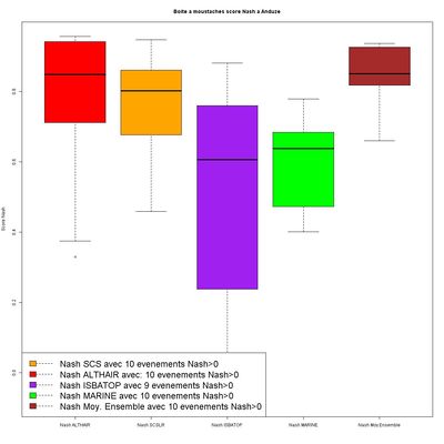
| + | The most interesting result deals with the fact that even the worst model brings an added value to the ensemble performance : the performance of the multi-model is greater than the performance of each modl taken individually on 2 catchments ( out of 3). Furthemore, the spread of NASH - on the different event - is thiner for the mult-model. | ||
| + | |||
| + | [[File:res_mm.jpg|400px]] | ||
| + | |||
| + | === Uncertainties due to the forecasted rainfall === | ||
| + | |||
| + | == What do we learn from past events ? == | ||
| + | |||
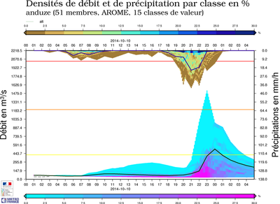
| + | == What is the most appropriate way to visualize the outputs ? == | ||
| + | |||
| + | [[File:alt_and_1DST_20141010000000.png|400px]]<big><big><big> | ||
| + | |||
| + | == Building the real-time chain == | ||
| + | |||
| + | |||
| + | == Equipe Projet == | ||
| + | |||
| + | |||
| + | '''Pilotage''' : Céline de Saint-Aubin, Léa Garandeau, Arthur Marchandise<br /> | ||
| + | |||
| + | '''Contributeurs''' : Céline Sorbet, Céline de Saint-Aubin, Arthur Marchandise, Vivien Pourret, Yann Laborda, Fabrice Mannessiez, Kévin Larnier | ||
| + | |||
| + | '''Stagiaires''' : Lylian Cortes, Olivier Audouin, Sébastien Delecray | ||
| + | |||
| + | '''Partenaires''' : Centre National de la Recherche Météorologique (CNRM), Institut de Mécanique des Fluides de Toulouse (IMFT), Hydrosciences Montpellier (HSM), Service de Prévision des Crues Grand Delta (SPCGD), Service de Prévision des Crues Méditerranée Ouest( SPCMO) | ||
| + | |||
| + | |||
| + | |||
| + | {{Auteur|NomAuteur=Arthur Marchandise}} | ||
Version actuelle en date du 26 octobre 2014 à 08:45
The CHROME project : Building and evaluating multi-ensemble hydrometeorological forecasting chain in Mediterranean catchments
CHROME is the acronym of "Couplage Hydrométéorologique RégiOnal Multi-Ensembles". This project started in 2011 and joins the expertises of hydrologists from French National Service for Flood Forecasting (SCHAPI) and of meteorologists from meteorological Service (METEO FRANCE).
CHROME project aims at bulding a multi-ensemble hydro-meteorological discharge forecasting chain on french Mediterranean catchments. Multi-ensemble means that both uncertainties on hydrological model structure and on rainfall forecast are considered. The mediterranean meteorological specificity -high and very space-variable rainfall intensity- is taken into account by using high resolution non-hydrostatic AROME NWP model outputs and four distributed rainfall/runoff model.
The different steps of this project are :
- assessing the weights of uncertainties in the different components of an multi-ensemble hydrometeorologic chain;
- evaluating the reliability and the sharpness of the forectased hydrographs thanks to hindcasts on past events;
- building, testing and improving a real-time coupled hydrometeorological chain;
- building user-friendly vizualisations of the chain outputs.
Sommaire |
[modifier] Material and Methods
The study area is the Cevennes area, in the south-eastern part of France. This area is regularly submitted to Flash Flood due to heavy rainfalls : the order of magnitude of rainfall amounts triggering severe floods is about 200 mm in a few hours. Specific discharges can exceed 5 m3/s/km2 on catchments of serveral hundreds of square kilometers. Three catchments are focused on : The Gardon d'Anduze (545 km2), the Cèze in Bagnols-sur-Cèze (1400 km2) and l'Ardèche in Vallon-Pont-d'Arc (2000 km2). These outlets have been choosen because they are part of the Vigilance map (see Vigicrues) of the avaibility of rating curves for high levels.
[modifier] Study of the uncertainties
[modifier] Uncertainties due to the model structure
The first task consisted in calibrating the parameters of the 4 models on the 3 outlets. The dataset included 8 events from 2001 to 2008. It was extracted from the OHM-CV databank (see Sevnol). Raw data are mainly produced by SPCGD.
Then the performance of each model was evaluated individually on the basis of a data collection of 8 events from 2008 to 2013.
The muti-model is built by computing, at each time step, the mean value of the four models discharge outputs.
Performance of each model is evaluated in term of : - average performance on the total hydrograph : a NASH criterium is computed on the hydrograph. Eventually, the mean value is computed
The most interesting result deals with the fact that even the worst model brings an added value to the ensemble performance : the performance of the multi-model is greater than the performance of each modl taken individually on 2 catchments ( out of 3). Furthemore, the spread of NASH - on the different event - is thiner for the mult-model.
[modifier] Uncertainties due to the forecasted rainfall
[modifier] What do we learn from past events ?
[modifier] What is the most appropriate way to visualize the outputs ?
[modifier] Building the real-time chain
[modifier] Equipe Projet
Pilotage : Céline de Saint-Aubin, Léa Garandeau, Arthur Marchandise
Contributeurs : Céline Sorbet, Céline de Saint-Aubin, Arthur Marchandise, Vivien Pourret, Yann Laborda, Fabrice Mannessiez, Kévin Larnier
Stagiaires : Lylian Cortes, Olivier Audouin, Sébastien Delecray
Partenaires : Centre National de la Recherche Météorologique (CNRM), Institut de Mécanique des Fluides de Toulouse (IMFT), Hydrosciences Montpellier (HSM), Service de Prévision des Crues Grand Delta (SPCGD), Service de Prévision des Crues Méditerranée Ouest( SPCMO)
Note : d'autres personnes peuvent avoir contribué au contenu de cet article, [Consultez l'historique]. |
 S'abonner à un flux RSS

