Prioritizing large dams projects in the West African region/en
 Language: Language: |
Français • English |
| International Office for Water. Oieau, place Sophie Lafitte BP 75 F-06902 Sophia antipolis (France) | ECOWAS Water Resources Coordination Center, 11 BP 1437 Ouagadougou (Burkina Faso) |
|---|---|
| c.brachet@oieau.fr | herve.levite@gmail.om |
| annatengnas@gmail.com | |
| ino@fasonet.bf |
Sommaire
|
Abstract
The potential for hydropower production in West Africa has been estimated to be 24 000 MW but only 10 % is currently developed. The rate for irrigation development is almost the same (12 %). Although the region has enormous renewable water resources, these are underutilized mainly due to economic reasons, a fact defined by IWMI as economic water scarcity. Indeed the majority of West African countries are poor and thus poorly prepared for large infrastructure investments and management. However, with impressive economic growth rates (5% to 10 %) and rapid transformations of societies (education, urbanization, democratization), the situation is quickly changing.
Given the high level of demand for electricity, food and potable water the construction of new water infrastructures is considered as a key priority for many decision makers. Investments in the sector can also address the need to regulate rivers against flooding and low flows, while preserving ecosystems. The Regional Economic Community of West Africa States (ECOWAS) entirely shares this view with its national partners as well as with trans-boundary basin authorities, crucial bodies in regional water management. Many large dam projects are currently in the pipeline in West Africa.
However, some of them have been waiting for a very long time, in some cases more than 50 years. In order to clarify the situation on the status of these projects, ECOWAS water unit launched in 2009, an initiative aimed at revitalizing a number of existing projects: the “Dialogue on large water infrastructures in West Africa”. The idea was to identify the projects that could have the most significant positive impact on regional integration. A panel of independent experts was created and given two major tasks i) establishment of criteria for identifying the most promising structures and ii) application of the criteria and proposal of a list of priority works that ECOWAS could promote.
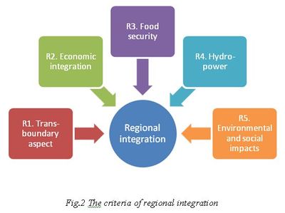
The first phase defined five axes of criteria with the perspective of regional integration;
- projects should have trans-boundary importance,
- a criterion on economic integration considered the fact that the structure should be managed by several states,
- the dams should contribute to regional food security,
- capacity to distribute hydro-power to a number of countries should exist
- environmental and social changes should be minimal on a trans-boundary scale.
Out of 39 projects studied, eight dams were selected at the end of the process. All dams will produce hydropower (a total of about 1000 MW), while half of the structures are multi-purpose dams, also intended for irrigation purposes (a total of about 75 000 ha).
Total cost is estimated to be more than $2 billion. The paper describes the process used by ECOWAS water center as well as the many challenges that countries could face while looking to fund their large dam projects.
- Keywords: water resources, dams, ECOWAS, regional integration, priorisation.
1. Introduction and objectives
Developing water resources has been put high on ECOWAS’ agenda, the regional economic community that unites fifteen West African countries (ECOWAS 2007). Not only ECOWAS but also other regional economic communities admit that water is a major engine for growth. For instance, the Southern African Development Community (SADC) signed, in 1995, and revised, in 2000, a well known protocol on shared waters (SADC, 2000) in order to facilitate transnational projects. In fact, all the Regional Economic Communities in Africa have been strongly encouraged, at international level, by United Nations agencies as well as at continental level by the African Union and the African Development Bank, to play an important role on this matter. In West Africa, a Permanent framework for coordination and monitoring (PFCM) of IWRM was set up in 2001 and, in 2004, the Water Resources Coordination Center was created to be the executive branch of the PFCM.
The needs for investments in water storage are indeed considerable. The region has huge water resources which are, however, poorly mobilized. West Africa only registers 214 of the 1282 African dams in FAO’s Aquastat database (ECOWAS 2010, FAO). Moreover many dams are underused for several reasons, such as silting, eutrophication and invading species (Atlas, 2010).
Energy production, more than food security, has for long been the main driver for investment in water storage in the region. Many large West African dam programmes have not even delivered the planned irrigation schemes due to high costs and poor cost-effectiveness. But with repeating food crises in the region and a recent increase of commodity prices (FAO), food production is again a strong driver within the region (World Bank, 2006, Barbier et al 2011). Moreover, securing domestic water supply for large towns (OECD, 2012) as well preventing floods – more and more frequently occurring due to climate change and climate variability - are two additional aspects of extreme importance.
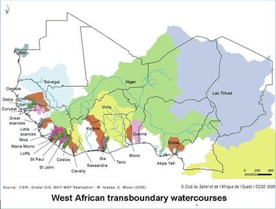
The development of large dams has been slowing down for the last 30 years, probably due to the difficulties encountered when raising the necessary funds, but also because of the transnational dimension of water resources that implies agreements of downstream and upstream countries united through river basin organisations. In West Africa, one finds, indeed, not less than 25 transboundary basins (fig. 1). Reinforcing the trans-boundary basin organisations has therefore become a measure to reinforce water cooperation between countries. With recent efforts by ECOWAS to support trans-boundary basins organisations, a large number of projects are now reactivated.
The ECOWAS WRCC guides, as a specialized technical unit devoted to the protection and development of the water resources, member states in their water management policies. In 2008, the WRCC launched a dialogue on large infrastructures (ECOWAS 2011) with support from IUCN. One of the objectives of the project was to understand the current status and if the investments so far have been beneficial for all users, including project-affected people (PAP). A second objective of ECOWAS was to try to identify the best projects that can be promoted in the sub-region. The second objective is described in thispaper.
2. Methodology
2.1 General methodology
The methodology was developed by a panel of experts that met several times during one year (2011) under the overall supervision of the WRCC. The Office International de l’Eau (OIEau), was in charge of the organisation of the panel and the syntheses of discussions. After identification of a list of projects and the choice of criteria, the experts decided to use a classical multi-criteria analysis method in order to select the best projects.
2.2 Establishment of a list of large infrastructure projects
Establishing a reliable list of large infrastructure projects was a challenging process, since reports are often dispersed and sometimes incomplete. Some countries, such as Ivory Cost – a very important country in terms of hydropower production, were in a delicate political situation and were thus unable to provide the required information.
It was also decided that all projects included on the list should be entirely new works. Existing infrastructures or projects under implementation were excluded. The member states as well as the main basin organisations (Niger Basin Authority, Volta Basin Authority, Organisation de Mise en Valeur du fleuve Gambie, Organisation de Mise en Valeur du fleuve Sénégal, and Mano River Union), were associated in the conception of the list. However, it is essential to bear in mind that the projects were at different stages of their existence; from inventory stage (projects that were only identified), to feasibility study or even to final design study, with or without environmental impact assessments. The list is therefore somewhat heterogeneous in terms of degree of information. Although the inventory was open to all types of larges infrastructures (such as irrigation schemes), only dams with reservoirs were selected (apart the case of Kaleta as a runoff river dam). Finally, a list of 39 dams was established.
2.3 Development of criteria for regional integration
The first task of the team was to establish of a list of prioritization criteria for projects that are likely to foster regional integration. By regional integration one refers to ”the process in which states enter into a regional agreement in order to enhance regional cooperation through regional institutions and rules” (Wikipedia, OECD Atlas 2007). ECOWAS considers that this regional integration should be a major achievement of almost all its policies.
The choice of criteria was done in a participatory manner through a consultative workshop (April, 2011), including basin organisations and technical partners. Five criteria were suggested for assessing the interest of a project from a regional integration perspective (fig 2).
2.4 Application of the criteria
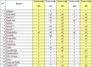
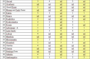
The analysis was done by the panel of experts using the following rules: each criterion was scored from 1 (for highest performance) to 5 (for lowest performance). This permitted 5 progressive scoring degrees. A criterion can include two or three indicators of various types: numerical indicators, logical indicators (“yes / no”) or level indicators (for example “low - medium – high”). The main criteria (R1 to R5) are described in detail below.
R1. Trans-boundary aspect
The first indicator provides information on the upstream/downstream position of the dam according to the following four levels:
- a. Project which are not located on an international river
- b. Project located on an international river without country downstream;
- c. Project located on an international river, with at least two countries downstream;
- d. So-called international projects, i.e. situated across a river forming the border between two States.
The second indicator deals with the number of countries located downstream the dam.
R2. Economic integration
In order to consider the international importance of the project, two indicators have been identified:
- The level of common interest shared through mutual agreement between several States (yes/no);
- Ratio between project investment (m$)/ normal reservoir volume (hm3).
R3. Food security
Again two indicators were chosen:
- Area directly irrigated by the project against reservoir volume
- Existence of a city of more than 50,000 inhabitants at a maximum distance of 150 km from the project (to facilitate the marketing of products).
R4. Hydropower production
This criterion shows whether or not the project will supply electricity to several countries. The first indicator describes the project connection to an electric grid such as the WAPP interconnection sub-networks: the costal ridge, OMVG-OMVS development, and interzones platform. The second indicator represents the guaranteed energy production (GWh) theoretically supplied to the power grid, divided by structure’s normal reservoir volume.
R5. Environmental and social impacts
This criterion describes the scope of environmental and social changes expected at transboundary scale., Two indicators are proposed:
- Filling ratio: corresponds to the normal reservoir volume against average annual volume supplied from the structure and gives an indication in particular, on the downstream trans-boundary impacts due to river regulation (changes in minimum flow and flood pattern);
- The importance of the reservoir’s absolute area, which indicates the upstream impacts (loss in natural environments and heritage, displaced persons).
- An indicator of the dam’s position within the basin, comparing the active river basin area controlled by the dam with the total river basin in maritime river mouth, measures the relative up-stream or down-stream position of the structure within the basin.
2.5. Example of ranking results
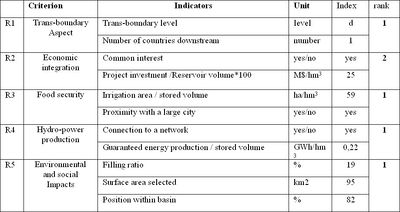
An example of the detailed ranking done for the Adjarala dam is given in the table 4.
3. Results
3.1 List of projects:
The list of works, accepted as prioritised projects, is per itself an important first result. It gives an idea of the dynamism and the demand of the sector, as well as on the market of dams’ development.
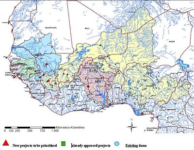
Out of 39 projects, 17 projects are situated in the Niger River basin, which is the largest catchment of the region. This reflects the fact that huge efforts have been done to support the Niger basin authority for more than ten years and that a development plan (PADD) has been instrumental in project development. The Volta River basin and the Gambia River basin both account for seven projects, while the Senegal River basin has five. Finally, one project is planned within the Mono River basin and one within the Kounkouré River basin. The projects are mainly situated in the west part of the sub region with Guinea being the country with the main potential of hydropower.
All dams that are in the list will be built for electricity production but only 30 % of scheduled dams are looking at agricultural production (given the available data). The fact that some countries are not included in the process was partly due of the conflicts and political instability at the time when the data collection and priorisation was carried out.
3.4 Results of the scoring
The scoring was done criteria by criteria for the 39 dams.
 |
|
 S'abonner à un flux RSS
